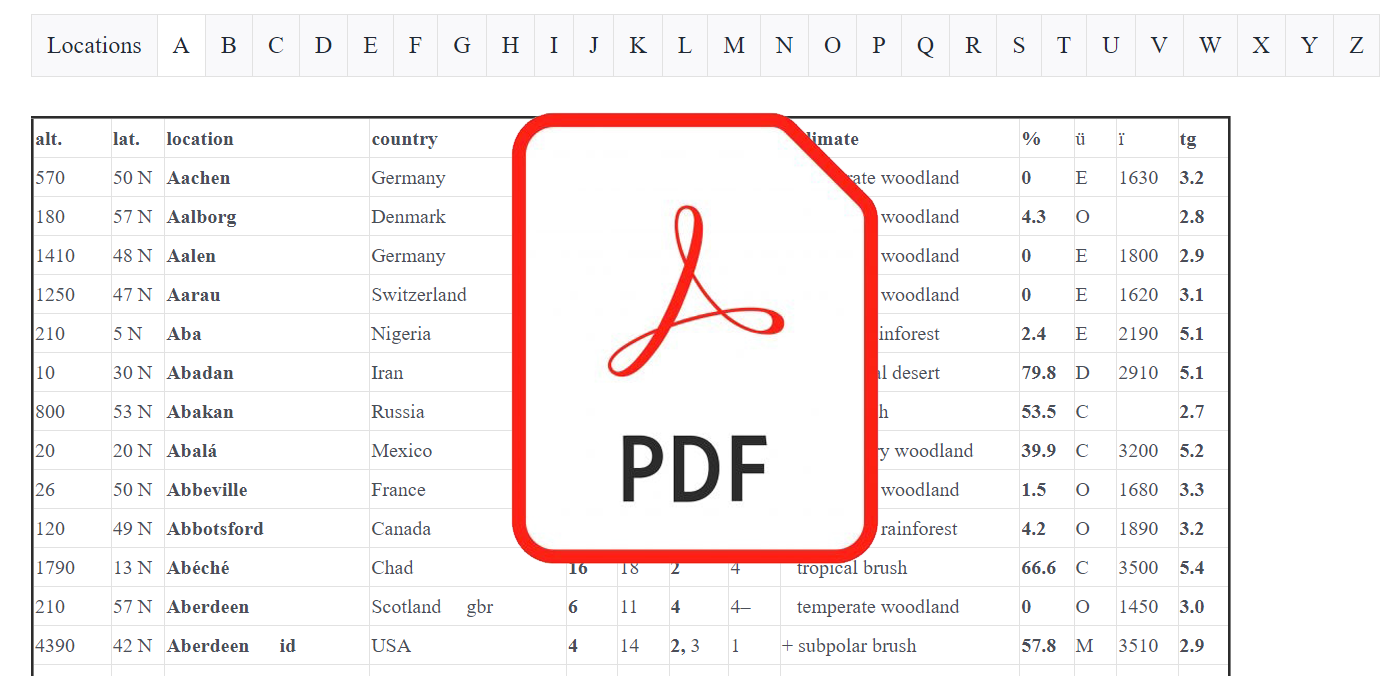
Description
- alt. Altitude, given in feet above sea level. It is not necessarily the altitude of the weather station, nor even the average altitude of the location. (alt)‒ refers to the highest point in a given location; (alt)+ to the minimum altitude; and (alt)a to the average altitude in locations where there is a significant difference between the lowest and highest altitude.
- location AP airport; NP National Park.
- zone The zone or coldest month of the year is in bold print. The summer-zone (warmest month) follows.
- grade The second number sometimes appearing immediately after the precipitation grade represents annual snowfall and is actually a zone number whereby, for example, “1” equals any climate having over 0 up to 1 foot/yr of snow on average. Snowfall totals are frequently absent in the source material.
- The summer grade is always regarded as June, July and August in the northern hemisphere and December, January, and February in the southern hemisphere. In a fairly small number of cases, mostly involving Mediterranean climates, summer is represented by July, August, and September in the northern hemisphere and January, February, March in the southern hemisphere. These are more in line with astronomical summer and are indicated by (summer-grade)a.
- climate The climate is identified as the temperature zone + precipitation and aridity indexes. If the temperature index indicates a different range, the name of the climate is modified by either a +, ‒, ‡ (double plus), or = (double minus) sign, for example, “+ temperate”, meaning a temperate zone and a subtropical grade or index.
- % aridity index; it is only exactly comparable between countries using the same definition of a precipitation day. The definition of a precipitation day also affects the grade and climate description, but much less so since the grade has been rounded off. An international standard is very much wanting here; 0.01” (= 0.04 mm; US), 0.2 mm (= 0.0078”; Canada), 0.5 mm (= 0.019”; Japan) work very well and are more or less compatible.
- ü geographic climate region, a super-general pattern of precipitation and, in some cases, temperature. These can be further delineated according to the needs of the user.
I = ice cap, with or without ice on it; T = tundra; O = oceanic; M = mediterranean (dry summer); C = central (wetter summer) and an aridity index over 16.6% for the year—if tropical, the dry season can occur in any part of the year; E = eastern or, if tropical, equatorial—a humid grade with an aridity percentage up to 16.6%; D = desert (but not in the case of the tundra or ice cap).
Designations according to altitude are not listed but are conveniently (and tentatively) identified as follows: High country (4500’+): SC = snow cap; AT = alpine tundra; A = alpine or polar highland; SA = subalpine or subpolar highland; M = montane or temperate highland; SM = submontane or subtropical highland; TM = tropical montane or tropical highland.
Middle country: upland (2250 to 4500’) and midland (1125 to 2250’); Low country or lowlands (0 to 1125’): PO, SP, TE, ST, TR, for example, TR-L = tropical lowland; TE-M = temperate midland.
- ï average annual sunshine hours‒another often widely divergent statistic.
- tg temperature grade or warmth index based on biotemperature. Locations identified by altitude follow the same system, for example, Adama Ethiopia: a “‒ tropical highland” or simply “‒ tropical montane”.
Classifications Download

Reviews
There are no reviews yet.