
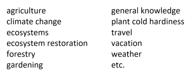
The following is a comprehensive and easy-to-use guide to climate classification. Just two numbers, the temperature and precipitation zones of a single location—preferably your own location to start—serve as a reference point to most of the system. The new standards can be easily applied to many topics:
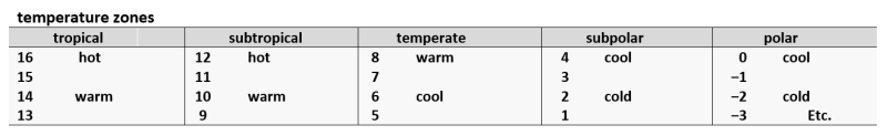
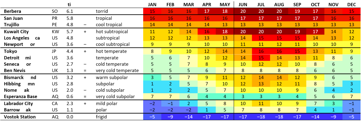
- The few zone 17 climates that have been found are included in the hot tropical category.
- The polar climates continue to zone ‒18 and can also be divided into groups of 4. Not counting research and weather stations in locations which are otherwise uninhabited, at zone ‒10 Verkhoyansk Russia has one of the coldest winters on the planet.
seasons
The system of zones and grades can be used to define differences by seasons, months, weeks—all the way down to a single day in the case of the temperature zones.
In some climates the summer is wetter than the grade while in others it is equal (that is, when rounded off to the higher number) or lower than the grade. The minus symbol (–) is used when the rounded-off grades are equal, but the summer is in fact drier (for example, 3–); + when it is wetter. No symbol is necessary when the difference is very minor.
summer
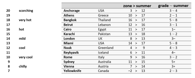
- Summer temperatures will be used to define the ice cap, tundra, and boreal forest. Summer precipitation will be used to define the Mediterranean and oceanic climates.
aridity index
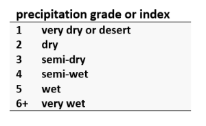
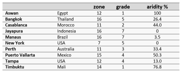
How dry is dry? The humidity grades can also be converted to define total annual dryness as a percentage called the aridity index. This figure adds greatly to our visualization of a particular climate and the transition of climates from one place or region to the next. 100% is equal to a desert with extremely little or no (measurable) precipitation at all. Desert climates begin at 66.6%. How close is your climate to a desert climate–to 66.6%?
aridity and the dry season
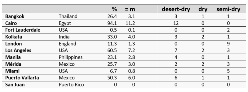
The aridity index as converted to a “monthly-like” total (m) sometimes matches or resembles the length of the dry season. For example, Puerto Vallarta has an aridity index of 50.3% and a desert-dry season which lasts 6 months of the year (50% of the year). In many cases, however, the amount of aridity and the number of dry months are not matched in the least, for example, London is 11.3% arid (= 1.3 months/year), although its aridity is actually spread out over the course of 9 (semi-dry) months.
defining seasons by zones
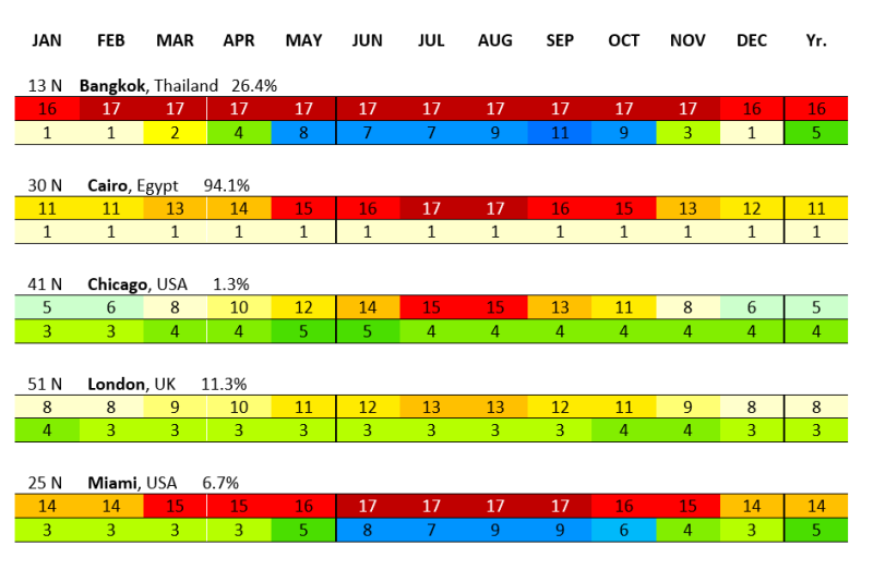
The zones sharply distinguish the wet and dry seasons or hot and cold seasons and detail the main differences within the seasons. For example, Bangkok has a wet season lasting 7 months, 6 months of which constitute a rainy season; the remaining 5-month long dry season includes 3 months of desert-dry weather. Miami also has a 5 month long dry season, but the numbers reveal that this season is specifically semi-dry, with moderate aridity in total—6.7% as opposed to Bangkok at 26.4%. Chicago has 4 months in the tropical range, that is, 2 months of hot summer and 2 months with mild summer temperatures. London has 2 “warm tropical months” or in other words a short mild summer.
warmth index
Also called the temperature grade or index (tg or ti), it is the sum total of average yearly “warmth” or temperatures above freezing—a measurement of seasonality as such.

The warmth index used in conjunction with the zones gives a more complete name of the climate according to temperature. Thus, it is one thing to say a given location is found in a semi-dry warm temperate zone, for example, and another thing to say that the same location has a hot temperate savanna climate, the latter name which includes the effects of seasonality.
The minus sign (‒) is used when the warmth index is lower than the range indicated by the zone. For example, Cartago Costa Rica is in a tropical zone (13), but the cooling effects of its high altitude (4710’ above sea level) and even its rainy climate results in a milder version of a tropical climate. This can be seen once its warmth index is taken into account, 4.97 or subtropical grade 5 once rounded to the higher whole number, hence, ‒tropical or cool tropical.
A few locations are two ranges warmer (‡, used as a double plus sign) or two ranges cooler (=, intended as a double minus sign, not an equal sign).
ecological names
Summer temperatures are used to define the ice cap, tundra, and boreal forest, whereas the remaining ecological grades are identified by their precipitation and aridity indexes as displayed below. The actual or historical ecosystem can be modified by any number of factors beyond our “basic climate numbers” and so should not be confused with the name of the climate.

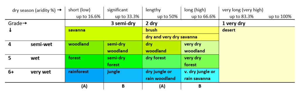 The dry and very dry savanna are conveniently located in the brush rectangle. The very dry savanna begins at 50.01% like the other very dry climates.
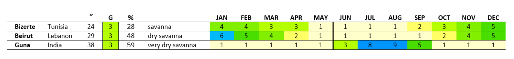
- A designation such as “dry forest” refers to a seasonally dry forest or a forest with a lengthy dry season. Hence, it is not a forest with less precipitation on average, but a forest with more precipitation on average, except that this precipitation is more heavily concentrated seasonally. Not all “decidedly seasonal” climates, for example, Bizerte Tunisia shown below, result in an alteration of the name of the grade.
- The transition from the brushland to the desert occurs at 66.6% in the vast majority of cases. In all cases the grade is used in the name of the climate, not the aridity percentage.
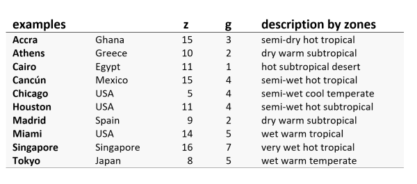
Take the short “climate guide.ai tour” below. The numbers give us an accurate sense of the climatic “distance” between one location and another, making this model very practical and easy to use.

Buy now for your guide to thousands of locations worldwide and a review of climate classification, including the USDA cold-hardiness zones, Koppen climate classification, and Holdridge life zones.